Weather disaster
Landslides Kill 15, Floods Displace 220,000 Across Mindanao
July 24, 2026 · Joshua S Bariñan
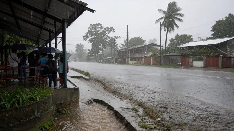
The heavy rain PAGASA warned about on July 8 turned deadly two days later. A landslide in Malapatan, Sarangani killed 10 people, and a separate slide in Calanogas, Lanao del Sur killed 5 more and left 6 missing, as Habagat and Typhoon Inday saturated ground already weakened by June's earthquake. Flooding also spread across the Bangsamoro region, growing from about 220,000 people on July 10 to more than half a million by July 13, as Malacanang pledged immediate national relief. The monsoon returned on July 22, flooding parts of South Cotabato, Davao City, and Cotabato.
Landslide buries two families in Malapatan
A landslide struck Sitio Fandaw in Barangay Poblacion, Malapatan, Sarangani province before dawn on Friday, July 10, burying two houses occupied by the Maladian and Yaton families. The Malapatan Municipal Disaster Risk Reduction and Management Office said rescuers recovered 10 bodies: Alejandro Maladian, Bina Binaton Maladian, Jordan Binaton Maladian, Weljay Maladian, Bonbon Cawsri, Therd Yaton Dawang, Prince Yaton Dawang, Save Yaton Dawang, and Daniel Binaton Dawang. A tenth victim, Ricky Ben, was rushed to a hospital but was declared dead on arrival.
OCD Region 12 director Rodrigo Sosmeña said prolonged heavy rain saturated the soil before the slope gave way, and all 10 victims had been recovered from the debris by Friday morning. Malapatan MDRRMO chief Mark Christopher Quiño said at least 115 families were evacuated and are staying in three evacuation centers, where the local government has distributed relief packs.
Quiño said the community is still recovering from June's earthquake while now facing new flooding from the typhoon. 'Una dasal po ang kailangan namin dito dahil di pa kami nakakabangon sa lindol, meron na namang mga pagbaha dulot ng bagyo,' he said, asking for prayers as the area had not recovered from the earthquake before the new flooding hit.
Five dead, six missing in Calanogas, Lanao del Sur
Hours earlier, at around 2:30 a.m., a hillside collapsed onto homes in Barangay Ngingir, Calanogas, Lanao del Sur, after two days of continuous rain loosened the slope. Barangay officials and police recovered the bodies of five villagers: Norhana Ali, Akmad Camar, Naifa Mansawi, Juhary Muhshin, and Norhaya Camar.
Six more residents remained missing as of Friday: Mujahid Abdulmajid, Mobairah Abdulrashid, Norhasan Abdulrashid, Arab Lilikan, Norlin Ali, and Norhanima Ali. Two other villagers were injured. Police Regional Office spokesperson for the Bangsamoro Autonomous Region, Capt. Steffie Salanguit, attributed the slide to rain from Super Typhoon Inday, known internationally as Bavi.
Roads leading to the site were impassable to vehicles, forcing rescuers from the Calanogas Municipal Police, the Bureau of Fire Protection, the municipal disaster office, barangay officials, and volunteers to walk about 10 kilometers before reaching the scene around 6 a.m. Crews used manual digging and mechanical equipment to extricate victims trapped under the mud and rock.
Floods spread across BARMM
The same rains triggered massive flooding across the Bangsamoro Autonomous Region in Muslim Mindanao. Bangsamoro READi, the region's disaster response office, first counted about 44,000 families, some 220,000 people, as of July 10. The total climbed through the week, reaching 103,218 families, or 516,090 people, across 328 barangays by July 13, and later passing 570,000. Most of the affected live in Maguindanao del Sur, Maguindanao del Norte, and Lanao del Sur, with 5,107 families sheltering in 37 evacuation centers and 33 houses destroyed.
The marshy town of Sultan sa Barongis, Maguindanao del Sur, has the most affected families, rising from 4,825 on Thursday to 5,655 on Friday, followed by Ampatuan, Datu Saudi Ampatuan, and Guindulungan. Most of these towns sit near the roughly 220,000 hectare Ligawasan Marsh and the Pulangi River, low lying terrain that floods easily during prolonged monsoon rain.
In Talayan, Maguindanao del Sur, flash floods swamped the Cotabato Isulan highway in Barangay Tambunan, and about 100 families evacuated in Parang, Maguindanao del Norte after the Nituan River overflowed. Bangsamoro READi director Muhammad Farzieh Abutazil said the Emergency Operations Center is under Blue Alert status, with Quick Response Teams deployed to Parang and Talayan and 400 additional Philippine National Police personnel sent to support flood relief across Mindanao.
On July 14, Malacanang said immediate relief would reach the region. Special Assistant to the President Antonio Lagdameo Jr. spoke for President Ferdinand Marcos Jr., who had placed agencies on full alert as Inday entered Philippine waters. National and local agencies reported more than 16.4 million pesos in food and other aid, and by July 13 the regional death toll from the flooding stood at seven, all from the Calanogas landslide, as searchers recovered more of the missing.
Why the ground gave way twice in a month
The rain came from the habagat, the southwest monsoon, intensified by Super Typhoon Inday, known internationally as Bavi, which entered the Philippine Area of Responsibility on July 8 without making landfall in the country. Its wide wind field kept feeding moisture into the monsoon even as the storm's center stayed hundreds of kilometers away.
The landslides in Malapatan and Calanogas both struck ground already weakened by the magnitude 7.8 earthquake that hit off the coast of Sarangani on June 8, the strongest to hit the Philippines since the 1976 Moro Gulf earthquake. Slopes shaken loose by a major quake tend to stay unstable for months, making them more likely to collapse once heavy rain returns. The Office of Civil Defense reported 74 flooded areas across Northern Mindanao, SOCCSKSARGEN, and the Bangsamoro region, and was verifying reports of two drowning deaths in Bukidnon during evacuation.
Rough seas and gusty winds
The enhanced monsoon and Inday's periphery are producing strong gusts, reaching gale strength in exposed coastal and upland areas across most of Mindanao. Seas are hazardous along the eastern and southern seaboards of Davao Oriental, and off Dinagat Islands, the Siargao and Bucas Grande Islands, and Surigao del Sur.
PAGASA advised operators of small vessels to stay in port until the winds and waves ease.
A separate gale warning was in force for the northern and eastern seaboards of Luzon and the eastern seaboard of the Visayas, where sea travel was called risky for vessels of any size. Mariners in those waters were told to stay in port or seek safe harbor until conditions improved.
What comes next
PAGASA said Inday continued to weaken and was expected to exit the Philippine Area of Responsibility by Saturday, July 11, before making landfall in China around July 12, which should ease the rain driving both the landslides and the flooding.
Classes remained suspended Friday in Iligan City, Maguindanao del Norte, and several towns in Maguindanao del Sur, including Datu Piang, Datu Salibo, Shariff Saydona Mustapha, Guindulungan, Datu Saudi Ampatuan, Datu Abdullah Sangki, Ampatuan, Sultan sa Barongis, and Shariff Aguak. Search operations for the six missing Calanogas residents were ongoing, while Malapatan's 115 evacuated families remained in evacuation centers pending assessment of their damaged homes.
The monsoon floods return on July 22
Two weeks after the deadly landslides, the habagat drove a fresh round of flooding across the region on Wednesday, July 22. In Barangay Cannery Site, Polomolok, South Cotabato, floodwater ran strong enough to sweep parked motorcycles, and residents formed a line to haul them to higher ground before the current carried them off. No one was hurt.
In Davao City, floodwater in Barangay Mandug stalled motorcycles and a pedicab and blocked a road until the water drained. In M'lang, Cotabato, fallen trees and branches closed several roads, and the municipal disaster office cleared them through the day. Flooding and a landslide in nearby Antipas damaged farmland, with the local government putting the loss at about 2.3 million pesos and helping more than 400 affected families.
PAGASA kept much of Mindanao under a yellow rainfall warning on July 23, covering Maguindanao del Norte, Cotabato City, South Cotabato including General Santos, Sultan Kudarat, Davao Occidental, Lanao del Sur, Sarangani, and Maguindanao del Sur, and warned again of flooding in low areas and landslides on saturated slopes.
Sources and verification
Reader response
- Views
- 11
- Shares
- 0
- Rating
- Not rated
- Comments
- 0