Mindanao earthquake
The Philippines' Strongest Earthquake Since 1976: June 2026 Sarangani Quake
July 20, 2026 · Joshua S Bariñan
A magnitude 7.8 Mindanao earthquake struck offshore Sarangani on June 8, 2026, damaging General Santos City, Sarangani, South Cotabato, and Davao Occidental while triggering tsunami warnings, thousands of aftershocks, and a wider debate about Cotabato Trench preparedness.
What happened in the June 2026 Mindanao earthquake
The June 2026 Mindanao earthquake struck offshore from Sarangani on the first morning of the school year, while students, parents, workers, and commuters were already moving through towns and city centers. The shaking was felt across Mindanao and reached communities well beyond the nearest coastal towns.
The epicenter was reported about 32 kilometers southwest of Maasim, Sarangani, with PHIVOLCS attributing the event to tectonic movement along the Cotabato Trench. General Santos City reported destructive Intensity VII shaking, while Malapatan, Sarangani recorded Instrumental Intensity VIII, the highest instrumental reading reported anywhere affected by this earthquake.
The 7:37 a.m. timing may have helped. Many students were still outside for flag ceremonies when the quake hit, not yet inside classrooms. That may be part of why school building collapses did not kill more people.
The dead, the injured, and the missing
By July 1, the Office of Civil Defense put the confirmed death toll at 88: 33 in Sarangani, 24 in South Cotabato (22 in General Santos City and 2 in Tupi), 20 in Davao Occidental, and 1 each in Davao del Sur and Bangsamoro. Twenty four people remained missing and 1,316 were listed injured.
Nearly 113,300 homes were damaged or destroyed across Mindanao by that count, up from the roughly 74,700 houses reported in the weeks right after the quake. Sarangani, Jose Abad Santos, Glan, and Malapatan carried the highest share of affected homes, while more than 30 percent of General Santos City's housing stock was damaged.
The deaths were not tied to one dramatic image alone. The risk was broader than the Jollibee collapse video: warehouses, homes, schools, hospitals, barangay halls, bridges, and slopes all became danger points.
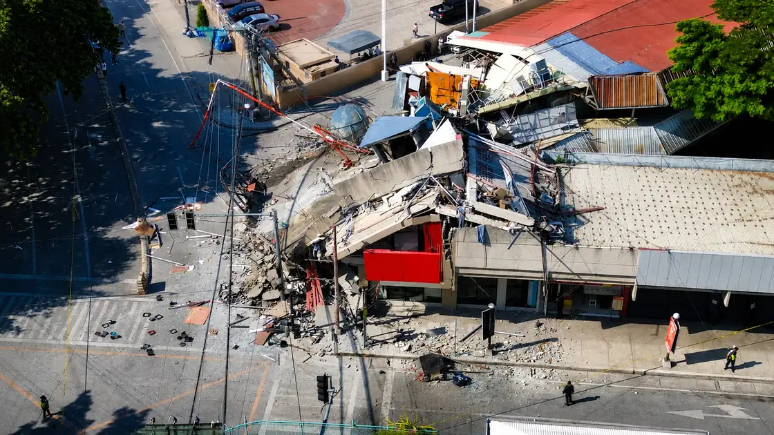
General Santos City damage after the Mindanao earthquake
One of the most widely circulated images from the disaster came from General Santos City, where a commercial building that housed a Jollibee branch, Love Radio GenSan, and DZRH News FM suffered a major collapse. Jollibee later said all of its employees were safe and accounted for.
Two people in General Santos City died when a wall at the Century Pacific Food warehouse collapsed.
The city also reported damage to Notre Dame of Dadiangas University, major city hall damage, and hundreds of damaged homes. The working brief listed 397 houses collapsed and 1,430 others partially damaged. Commercial centers including SM City GenSan and Robinsons were closed for safety inspections after the quake.
St. Elizabeth Hospital carried one of the clearest human pictures of the disaster. Hospital management said its outpatient building would need four to six months to rebuild before it could reopen. Patients were treated outdoors in tents under the June heat, including a young mother who gave birth on the hospital grounds on Tuesday morning, June 9.
General Santos City declared a state of calamity, which put a price freeze in place and opened emergency response funds. Philippine Airlines and Cebu Pacific canceled all commercial flights through June 11. Seventeen flights were canceled on the first day. The airport stayed open for military, government, and humanitarian use.
Glan, Sarangani, and Mindanao towns closest to the epicenter
Glan became one of the clearest examples of how isolation complicated rescue operations after the Mindanao earthquake. Landslides and bridge failures cut road access for nearly two days, forcing responders to rely on helicopters to reach injured residents and isolated communities.
Clearing operations had not yet begun in many parts of Glan as of June 10, according to the working brief. For one of Sarangani's largest towns, that isolation was not a side detail. It shaped the entire rescue picture because responders could not simply drive in and count damage house by house.
Malapatan recorded Instrumental Intensity VIII, higher than General Santos City. Maasim, the town nearest the offshore epicenter, reported collapsed and damaged homes. Sarangani declared a province wide state of calamity on June 10. Glan and Alabel each declared their own, unlocking emergency funds and local response powers.
South Cotabato, Koronadal, and road damage
In South Cotabato, Mindanao earthquake damage reached General Santos, Koronadal, Tupi, Banga, and road corridors across the province. Koronadal lost electricity, water, and internet at the same time. The regional center was not watching from the sidelines. Banga reported bridge damage. Road links between Tboli and General Santos were cut. Court operations in several areas were suspended while engineers inspected buildings.
Jose Abad Santos and Davao Occidental
Davao Occidental experienced some of the most severe landslide impacts following the Mindanao earthquake. Jose Abad Santos suffered two separate landslides that killed residents and left communities cut off during the first days of response. As of the latest casualty update found by June 29, Davao Region had 21 confirmed deaths and 13 people still missing.
Residents of Balut Island, including injured people, elderly residents, and a mother with an infant, had to be airlifted to Davao City for medical care. The SMC Malita Coal power plant in Davao Occidental also tripped offline after the quake, contributing to the regional power outage.
Schools, students, and the first day of classes
The quake struck on the first day of school for many communities, which made schools one of the most emotionally visible parts of the disaster. As of June 8, the working brief listed 8,642 schools affected across Mindanao. By June 10, DepEd confirmed 1,022 public schools damaged.
More than 3.2 million students and about 129,000 teachers and school personnel were affected across five regions.
Cotabato City had its own eerie timing. Students at Cotabato City Central Pilot Elementary School were in the middle of a scheduled earthquake drill when the real quake hit. What was supposed to be practice became the actual event.
Power, transport, and public services
At peak disruption, about 157,000 electricity consumers had no power. Two power plants tripped offline: the SMC Malita Coal facility in Davao Occidental and the Sarangani Energy Corporation plant in Maasim. Power to South Cotabato, Sarangani, and General Santos was restored by the afternoon of June 9, with full grid normalization targeted for the end of the week.
Transport disruption centered on General Santos City airport. Philippine Airlines and Cebu Pacific canceled commercial flights through June 11, but military, government, and humanitarian flights continued. In Davao City, the Bolton Bridge southbound lane was also closed pending inspection, affecting movement in the region's largest city.
Tsunami warnings and aftershocks
Because the Mindanao earthquake was offshore, tsunami warnings were issued for coastal areas in the southern Philippines and for nearby countries including Indonesia, Malaysia, Taiwan, Papua New Guinea, Japan, and Palau. The warnings were later lifted, but the international reach showed why Cotabato Trench events are not only local stories.
Waves reached up to 1.4 meters along Mindanao's southern coast and 1.5 meters at Talengan in North Sulawesi. At least one person drowned and others went missing after being swept by strong currents near the General Santos City coast, even after official warnings had been lifted.
PHIVOLCS warned that aftershocks could continue for more than a month. Thousands of aftershocks followed the mainshock. By June 9 morning, PHIVOLCS had logged about 1,100 events. By June 10, the count passed 2,000. By June 15, it reached 6,058. At least three of those were magnitude 6.0 or stronger. The largest early aftershock reached magnitude 6.7, recorded within hours of the June 8 mainshock. On June 15 at 11:30 p.m., a magnitude 5.5 aftershock near Glan was felt at Intensity V in General Santos City, Sarangani, and Davao Occidental. PHIVOLCS warned the sequence could continue for more than a month. Residents in affected areas should treat aftershock advisories as an ongoing safety issue, especially around cracked walls, damaged schools, unstable slopes, bridges, hospitals, and public buildings. Old earthquake footage from other events started circulating as if it were happening now. For anything that affects your real world decisions, please stick to official sources only.
Marcos visit, aid, and government response
President Ferdinand Marcos Jr. flew to General Santos City on June 10. He visited St. Elizabeth Hospital, Romana C. Acharon Central Elementary School, and General Santos National High School, then oversaw the distribution of financial assistance at the city oval. He was accompanied by DPWH Secretary Vince Dizon, DepEd Secretary Sonny Angara, DSWD Secretary Rex Gatchalian, and Mayor Lorelie Pacquiao.
The national government announced P50,000 in cash aid for each family that lost someone in the earthquake. General Santos City was also allocated P100 million from the Local Government Support Fund for city hall reconstruction and related infrastructure. As of June 16, more than ₱156 million in assistance had been distributed to affected families. Infrastructure damage was estimated at ₱1.07 billion, while agricultural losses reached ₱29.8 million. Fourteen cities and municipalities were placed under a state of calamity.
Marcos said mental health support from DOH would be available for students and school staff. The GSIS Emergency Loan was open to qualifying members in calamity areas until September 7. BIR extended tax filing deadlines in General Santos City, Sarangani, and South Cotabato to June 30. The CBCP asked bishops to hold a special collection at Sunday masses on June 14 for earthquake victims. Cebu and Pangasinan also sent financial aid.
Why the Cotabato Trench matters
The Cotabato Trench has been associated with some of Mindanao's major historical earthquake and tsunami events, including the 1918 Celebes Sea earthquake at magnitude 8.3, the 1976 Moro Gulf earthquake at magnitude 8.0 to 8.1, and the 2002 Southern Mindanao earthquake at magnitude 7.5.
The trench was being actively monitored before June 8, which is why the June 2026 quake should be read as both a current emergency and a long term planning lesson for coastal evacuation, school safety, hospital redundancy, landslide response, mental health support, and local communication systems across southern Mindanao.
Sources and verification
Reader response
- Views
- 102
- Shares
- 4
- Rating
- Not rated
- Comments
- 0