Davao Region / Davao Oriental / Mati
Sleeping Dinosaur Viewpoint
Best for
- Scenic viewpoint
- Mati
Map address
Barangay Badas (Badas Point), Mati City, Davao Oriental 8200, Davao Region
Why it matters
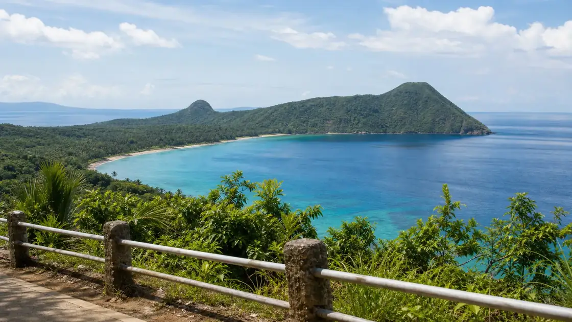
The Sleeping Dinosaur is a 579 hectare island landmass in Pujada Bay near Mati whose ridge line looks like a dinosaur at rest when seen from the highway. The highest point is 51 meters above sea level. Most travelers spot it on the descent into Mati from the Davao side because it appears right as the mountain roads level out. The viewpoint is at the highway edge, so photos come with passing trucks. A trail along the spine takes 30 to 60 minutes. A local legend calls the formation Rex, a kind dinosaur put to sleep after being poisoned by a rival named Dazzle.
Local context
The Shape of a Giant
As you descend the winding mountain passes toward Mati, the Sleeping Dinosaur suddenly appears on the horizon. The resemblance is striking: a long, green ridge that follows the curve of a neck, a humped back, and a tail submerging into the Pacific.
While some call it a dinosaur, many locals and geologists note its similarity to a plesiosaur resting in the calm waters of Pujada Bay. Once the silhouette is pointed out against the turquoise backdrop of the bay, it becomes the defining visual anchor for the entire region.
The formation looks like an island but is actually a peninsula connected to the mainland of Davao Oriental. Its distinctive "dino" shape is accentuated by the low lying tropical vegetation that gives it a textured, reptilian appearance from a distance.
For many travelers, spotting the dinosaur is the official signal that the long drive from Davao City is almost over. The entire Sleeping Dinosaur island covers about 579 hectares and is a protected part of the wider Mati seascape. Most travelers see this spot as the official welcome to Mati because it appears just as you descend the winding mountain roads.
Photography and Lighting Tips
For the best photos, timing is everything. Arriving between 5:30 AM and 6:30 AM allows you to catch the sunrise as it crests over the Pacific, illuminating the "back" of the dinosaur while keeping the colors of Pujada Bay bright.
During the early morning, the air is usually clearer, and the morning mist often clings to the surrounding valleys, adding a layer of depth to your shots. A wide angle lens (16mm to 24mm) is ideal for capturing both the sweeping curves of the highway in the foreground and the entire length of the dinosaur.
If you are using a drone, be cautious of the high winds that frequently whip through the mountain pass in Barangay Dawan. An aerial shot from directly above the "neck" area reveals the narrow ridge trail that many hikers now explore.
Road Conditions and the Journey
The road to the viewpoint follows the Davao-Mati Road. The final 30 kilometers before Mati are famous for "S-curves," which are tight turns through the mountains.
The road is paved, but you need to drive carefully, especially when it rains and the road is slippery. If you are driving from Davao City, expect a 3.5 to 4 hour trip.
Commuter vans from the Ecoland Terminal are a common alternative, but they drive aggressively on the curves. It is best to top up your fuel in Tagum or Pantukan before starting the final mountain ascent, as gas stations become infrequent until you reach the outskirts of Mati.
On Site Experience
There is a designated gravel parking area along the shoulder of the highway where you can safely pull over. On weekends, this spot can become quite busy with tour vans and motorcycle groups.
Several local entrepreneurs have built elevated wooden "selfie nests" or platforms that offer slightly higher vantage points; these typically request a nominal donation of ₱10 to ₱20 for upkeep. Local vendors at the deck sell native Mati coffee, cold drinks, and hot snacks like bibingka.
It is a great spot to stretch your legs and enjoy the sea breeze before the final 15 minute descent into the Mati city center. There is no official entrance fee for the public viewing area, making it one of the most accessible and rewarding stops in Mindanao.
Safe Stopping and Hiking
The viewpoint has limited space to pull over, so safe stopping matters. It works best as part of a Mati arrival route rather than as a standalone trip that requires backtracking from the city.
For those with more than a few minutes to spare, you can actually hike the ridge of the Sleeping Dinosaur. The jump off point is in Barangay Badas, just a few minutes past the main viewpoint toward the city.
The "Dino Trail" is a trek that takes about 1 to 2 hours. There is not much shade, so you should start early, before 7:00 AM, to avoid the heat.
The view from the "head" of the dinosaur looks back at the Mati coastline and the highway. The viewpoint is right on the edge of the highway so you should watch for passing trucks and buses while taking photos. There is a trail that lets you walk along the 'spine' of the dinosaur which takes about thirty minutes to an hour to complete.
Frequently Asked Questions
What is the best time to visit the Sleeping Dinosaur viewpoint?
Sunrise (5:30 AM to 7:00 AM) is the best time for photography and cooler temperatures. The afternoon sun can be very harsh and often creates a haze over Pujada Bay.
Is there an entrance fee?
Access to the main roadside viewing area is free. Some private platforms or selfie nests may charge a ₱10 to ₱20 fee.
How long is the drive from Davao City to Mati?
It typically takes 3.5 to 4 hours via private vehicle, depending on traffic in Tagum City and your pace through the winding S-curves.
Can you actually hike the Sleeping Dinosaur?
Yes, a hiking trail exists. The jump off is in Barangay Badas, and the trek takes about 1.5 hours. It is best done in the early morning due to the lack of shade.