Davao Region / Davao del Norte / Panabo
Panabo Mangroves Eco Park
Best for
- Eco park
- Panabo
Map address
Cogon-1, Barangay J.P. Laurel, Panabo City, Davao del Norte 8105, Davao Region
Why it matters
Panabo City had Davao del Norte's largest mangrove planted area as of 2017, at about 110 hectares. The Eco Park in Barangay J.P. Laurel is the public access point for that stretch of Davao Gulf shoreline. The boardwalk runs over the water through the mangrove stands, which provide nursery habitat for fish, shoreline protection, and perches for coastal birds. Mangrove planting still takes place here during government environmental programs. Early morning gives better bird activity and cooler temperatures.
Local context
A Forest on the Davao Gulf
Panabo City’s mangrove park is the most significant coastal habitat in a city otherwise defined by banana plantations and busy highway commerce. Spanning over 109 hectares along the coastline of Barangay J.P. Laurel, this forest is proof of years of reforestation work.
Developed in partnership with Davao del Norte State College, the park acts as a natural buffer that protects the Panabo shoreline from erosion and the increasingly intense storm surges associated with the Davao Gulf. The forest is dominated by Rhizophora apiculata, locally known as Bakauan Lalaki, with its complex network of prop roots.
These roots create a dense underwater forest that shelters juvenile fish, shrimp, and various crustacean species, making the park a nursery that supports the fishing livelihoods of the surrounding coastal barangays. Mangroves provide fish and crustacean nursery habitat, shoreline protection, carbon storage, and coastal bird habitat in Panabo's agricultural landscape.
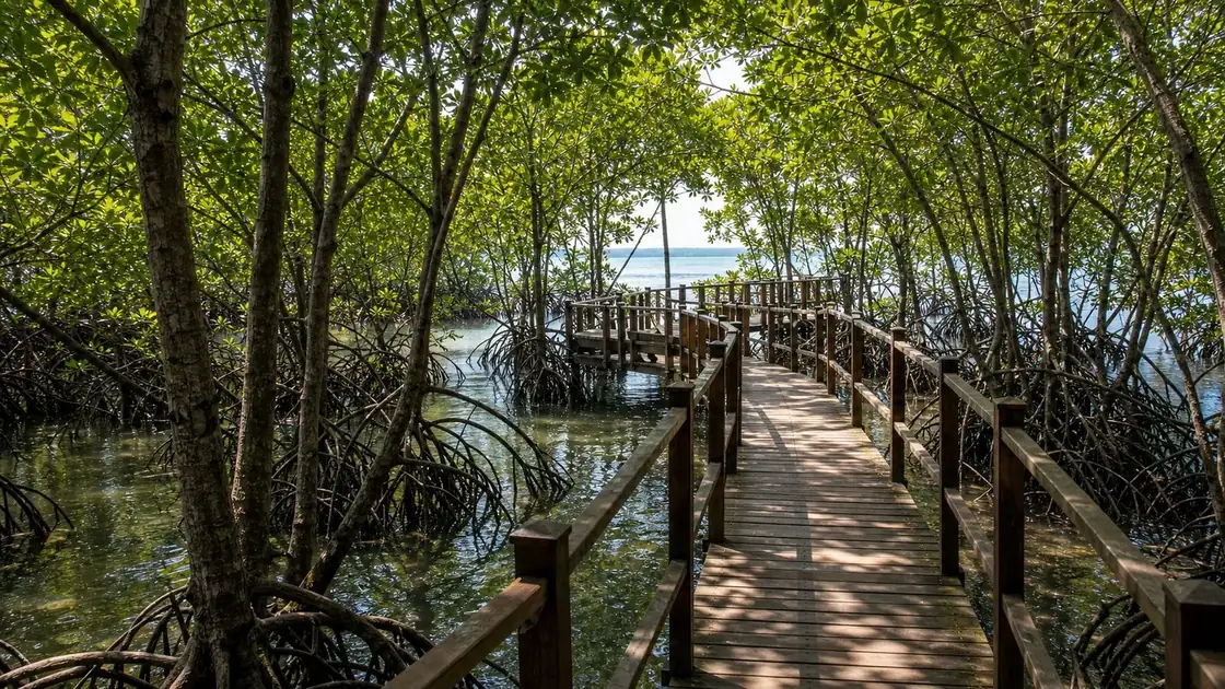
The J.P. Laurel Boardwalk
The primary feature for visitors is the J.P. Laurel Mangrove Boardwalk. This raised path, constructed from a mix of bamboo and concrete, allows you to traverse the deep mudflats and observe the mangrove root systems without causing damage to the delicate ecosystem.
Walking through the canopy of the older trees, you can see various wading birds, such as egrets and kingfishers, which use the park as a primary feeding and nesting ground. As of 2026, the boardwalk remains well maintained and acts as an outdoor classroom for local schools and environmental researchers.
It is a common site for community mangrove planting activities, especially during National Disaster Resilience Month, when residents gather to add new seedlings to the coastal fringe. The elevated path also gives you a clear look at the tidal movements that define the life of the forest.
Blue Carbon and Conservation
Mangroves are good at storing carbon dioxide. They can store ten times more carbon than forests on land.
The Panabo Mangrove Eco Park is a study site for measuring these carbon stocks. This scientific role has helped local conservation funding, keeping the 109 hectare expanse protected from urban encroachment. The park is managed by the City Agriculture Office with local fisherfolk organizations, balancing ecological health with the community’s traditional access to coastal resources.
Practical Visit Notes 2026
Access to the park is generally free, though a nominal environmental fee of ₱10 to ₱20 may be requested at the entrance for maintenance. The best time to visit is in the early morning, ideally before 8:30 AM, when bird activity is at its peak and the temperatures are still comfortable.
By midday, the humidity under the mangrove canopy can become intense. The park is located adjacent to the Panabo Seawall, which has its own active evening area of food stalls and coastal views.
If you are visiting for photography, the "golden hour" at the seawall creates striking silhouettes of the mangroves against the backdrop of Samal Island and the Davao Gulf. To get there, simply take a tricycle from the Panabo city center and ask for the "Mangrove Park" in J.P. Laurel. Early morning is the better observation window because wading birds and mangrove associated species are more active and temperatures are cooler.
Frequently Asked Questions
Is there an entrance fee for the Panabo Mangrove Eco Park?
Access is generally free, though some visitors may be asked for a ₱10 to ₱20 voluntary contribution or environmental fee at the entrance for the upkeep of the boardwalk.
What can I do at the Panabo Mangrove Forest Park?
The park is ideal for bird watching, coastal photography, and educational walks along the J.P. Laurel boardwalk. It is also a frequent site for community tree planting activities.
What is the best time to visit?
Early morning (6:00 AM to 8:30 AM) is the best time for bird watching and to avoid the midday heat. Late afternoon is great for visiting the nearby Panabo Seawall.
Why are the mangroves important for Panabo City?
They protect the shoreline from erosion and storm surges, act as a nursery for local fish and shrimp, and serve as a massive "Blue Carbon" sink that helps mitigate climate change.