Caraga / Agusan del Norte / Butuan
Agusan River corridor
Best for
- River corridor
- Butuan
Map address
Agusan River Corridor, Barangay Baan Riverside, Butuan City, Agusan del Norte 8600, Caraga
Why it matters
The Agusan River is one of the major river systems in Mindanao. It flows north through the Agusan Valley toward Butuan Bay. The river explains why people settled in Butuan. The balangay finds, trade, farming, and bridges all follow the river. It is used for transport and is part of the local heritage and ecology. People depend on it for their livelihoods. The city also manages the risks from floods and monitors water quality. The way Butuan meets the lower river determines where bridges and heritage routes are placed.
Place guide
Understanding Butuan Through the Agusan River
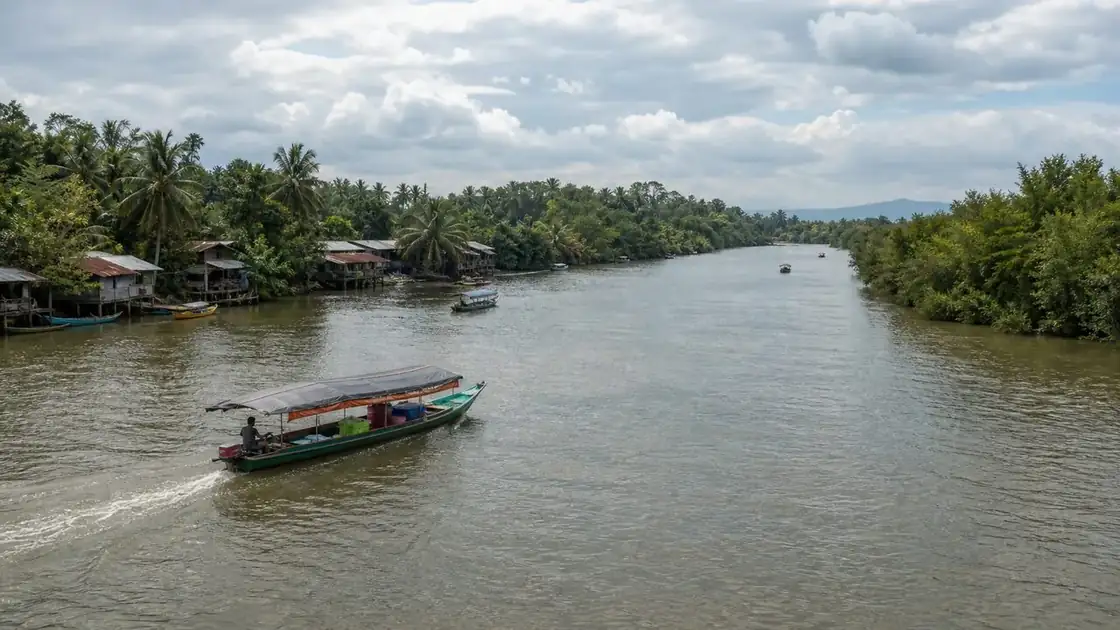
The Agusan River is the third longest river in the Philippines, running approximately 350 kilometers from its headwaters in Davao de Oro through the Agusan Valley and into Butuan Bay. Its watershed covers most of the Caraga region. The lower river corridor near Butuan is where archaeological evidence of the balangay boats was found. The river explains why a precolonial trading port of Butuan's scale existed here at all.
What to Observe from the River Corridor
From bridge vantage points in Butuan, especially the Magsaysay Bridge and older river crossing points, the river shows its width and the flat bottomed boats still used by river communities. Riverbank settlements, mangrove edges, and agricultural floodplains are visible. At certain seasons, water hyacinth patches appear, which communities manage as a recurring environmental challenge.
Flood Context
The lower Agusan River is a flood prone corridor. During heavy monsoon rains or prolonged rainfall events upstream, river levels rise rapidly and affect barangays along the riverbank. Residents near the corridor often monitor rainfall reports from Davao de Oro and Agusan del Sur for advance warning.
Route Pairing
The Agusan River is the physical context for Butuan's heritage sites. Visit the river corridor on the way to or from the Balangay Shrine Museum and the National Museum Butuan. The river to bay geography, with the city sitting on a bend where the river widens before Butuan Bay, explains the entire settlement logic.
Local context
Local details to know
Riverbank settlement, rainfall, upstream land use, and drainage all shape flood risk along the lower river. That includes Butuan side communities where water level, road access, and bridge placement matter in daily life.